Windmühle Dargun II: Unterschied zwischen den Versionen
Die Seite wurde neu angelegt: „{{Infobox Standort | landkreis = MSE (MC) | plz = 17159 | ort = Dargun | adresse = Fritz-Reuter-Straße | gemarkung = Gemarkung Dargun (133825), Flur 1, Flurstück 225/1 | gps = 53.903772 / 12.854455 | note_gps = DenkmalGIS: 33359046;5974947 | osm_iframe = <html><center><iframe width="425" height="350" src="https://www.openstreetmap.org/export/embed.html?bbox=12.851262688636782%2C53.90217640905967%2C12.857646346092226%2C53.9053684233338&am…“ |
Keine Bearbeitungszusammenfassung |
||
| Zeile 1: | Zeile 1: | ||
== 1. Standort == | |||
{{Infobox Standort | {{Infobox Standort | ||
| stand = NaT | |||
| landkreis = MSE (MC) | | landkreis = MSE (MC) | ||
| note_landkreis = NaT | |||
| plz = 17159 | | plz = 17159 | ||
| ort = Dargun | | ort = Dargun | ||
| Zeile 7: | Zeile 10: | ||
| gps = 53.903772 / 12.854455 | | gps = 53.903772 / 12.854455 | ||
| note_gps = DenkmalGIS: 33359046;5974947 | | note_gps = DenkmalGIS: 33359046;5974947 | ||
| osm_iframe = <html><center><iframe width="425" height=" | | osm_iframe = <html><center><iframe width="425" height="250" src="https://www.openstreetmap.org/export/embed.html?bbox=12.851262688636782%2C53.90217640905967%2C12.857646346092226%2C53.9053684233338&layer=mapnik&marker=53.903772446684336%2C12.854454517364502" style="border: 1px solid black"></iframe><br/><small><a href="https://www.openstreetmap.org/?mlat=53.903772&mlon=12.854455#map=18/53.903772/12.854455">Größere Karte anzeigen</a></small></center></html> | ||
}} | }} | ||
{{Zweispaltiger Inhalt Beginn}} | {{Zweispaltiger Inhalt Beginn}} | ||
{{Zweispaltiger Inhalt Links Beginn}} | {{Zweispaltiger Inhalt Links Beginn}} | ||
== 2. Denkmalstatus == | |||
{{Infobox Denkmalstatus | {{Infobox Denkmalstatus | ||
| schutzgut = Windmühle | | schutzgut = Windmühle | ||
| Zeile 17: | Zeile 21: | ||
{{Zweispaltiger Inhalt Links Ende}} | {{Zweispaltiger Inhalt Links Ende}} | ||
{{Zweispaltiger Inhalt Rechts Beginn}} | {{Zweispaltiger Inhalt Rechts Beginn}} | ||
== 3. Mühlenart == | |||
{{Infobox Mühlenart | {{Infobox Mühlenart | ||
| muehlentyp = Windmühle | | muehlentyp = Windmühle | ||
| formtyp = Erdholländerwindmühle | | formtyp = Erdholländerwindmühle | ||
| urfunktion = Getreideverarbeitung | |||
| nutzung = Wohnung | | nutzung = Wohnung | ||
| baujahr = 1864 | | baujahr = 1864 | ||
| Zeile 25: | Zeile 31: | ||
{{Zweispaltiger Inhalt Rechts Ende}} | {{Zweispaltiger Inhalt Rechts Ende}} | ||
{{Zweispaltiger Inhalt Ende}} | {{Zweispaltiger Inhalt Ende}} | ||
== | == 4. Bauzustand und Funktion == | ||
=== | === 4.1 Bauzustand === | ||
: | {{Infobox Bauzustand | ||
| bauzustand_jahr = 2025 | |||
| bauzustand = | |||
| stichpunkt_1 = | |||
}} | |||
=== 4.2 Technik === | |||
{{Infobox Technik | |||
| technik_zustand_jahr = 2025 | |||
| technik_zustand = | |||
| stichpunkt_1 = | |||
}} | |||
=== 4.3 Baubeschreibung === | |||
:; Bauweise | |||
:* Aufzählungspunkt 2 | :* Aufzählungspunkt 2 | ||
:* Aufzählungspunkt 3 | :* Aufzählungspunkt 3 | ||
== | == 5. Umgebung == | ||
== | == 6. Standortgeschichte == | ||
== 7. Dokumentation == | |||
== Bildergalerie == | == 8. Bildergalerie == | ||
<gallery widths="275" heights="320" perrow="3"> | <gallery widths="275" heights="320" perrow="3"> | ||
Datei: | Datei:Windmühle_Dargun_II_Bild_1.jpg|Bildbeschreibung | ||
Datei: | Datei:Windmühle_Dargun_II_Bild_2.jpg|Bildbeschreibung | ||
Datei: | Datei:Windmühle_Dargun_II_Bild_3.jpg|Bildbeschreibung | ||
</gallery> | </gallery> | ||
[[Kategorie:Windmühle|Dargun II]] | [[Kategorie:Windmühle|Dargun II]] | ||
Version vom 12. August 2025, 21:09 Uhr
1. Standort
Erfasser: n/a, Arbeitsstand: NaT
- Landkreis (1990):
-
MSE (MC)
NaT - PLZ, Ort:
-
17159 Dargun
- Adresse:
-
Fritz-Reuter-Straße
- Gemarkung:
-
Gemarkung Dargun (133825), Flur 1, Flurstück 225/1
- GPS:
-
53.903772 / 12.854455
DenkmalGIS: 33359046;5974947
2. Denkmalstatus
- Schutzgut:
-
Windmühle
- Listeneintrag (seit ...):
-
kein Denkmal
3. Mühlenart
- Mühlentyp:
-
Windmühle
- Formtyp:
-
Erdholländerwindmühle
- Urfunktion:
-
Getreideverarbeitung
- Nutzung:
-
Wohnung
- Baujahr:
-
1864
4. Bauzustand und Funktion
4.1 Bauzustand
- .. im Jahr 2025 :
- Zustandsbeschreibung:
4.2 Technik
- .. im Jahr 2025 :
- Zustandsbeschreibung:
4.3 Baubeschreibung
- Bauweise
- Aufzählungspunkt 2
- Aufzählungspunkt 3
5. Umgebung
6. Standortgeschichte
7. Dokumentation
8. Bildergalerie
-
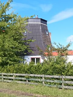 Bildbeschreibung
 -
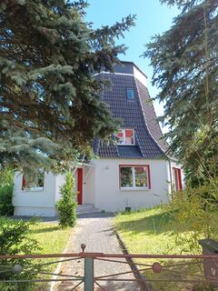 Bildbeschreibung
 -
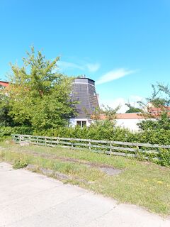 Bildbeschreibung


