Motormühle Stralsund: Unterschied zwischen den Versionen
| Zeile 1: | Zeile 1: | ||
== 1. Standort == | == 1. Standort == | ||
{{Infobox Standort | {{Infobox Standort | ||
| landkreis = VR | |||
| landkreis = | |||
| ort = Stralsund | | ort = Stralsund | ||
| adresse = Neue | | adresse = Neue Semlowerstraße, 18439 Stralsund | ||
| gemarkung = Gemarkung Stralsund (132576), Flur 24, Flurstück 38 | | gemarkung = Gemarkung Stralsund (132576), Flur 24, Flurstück 38 | ||
| gps = | | gps = 54°18'58.4"N 13°05'48.3"E | ||
| note_gps = DenkmalGIS: 33376185;6020372 | | note_gps = DenkmalGIS: 33376185;6020372 | ||
| bezeichnung = | | bezeichnung = Hafenmühle | ||
| osm_iframe = <html><center><iframe width="425" height="250" src="https://www.openstreetmap.org/export/embed.html?bbox=13.093573451042175%2C54.31460818492863%2C13.099533319473268%2C54.31779050727832&layer=mapnik&marker=54.31619937686897%2C13.096553385257721" style="border: 1px solid black"></iframe><br/><small><a href="https://www.openstreetmap.org/?mlat=54.316199&mlon=13.096553#map=18/54.316199/13.096553">Größere Karte anzeigen</a></small></center></html> | | osm_iframe = <html><center><iframe width="425" height="250" src="https://www.openstreetmap.org/export/embed.html?bbox=13.093573451042175%2C54.31460818492863%2C13.099533319473268%2C54.31779050727832&layer=mapnik&marker=54.31619937686897%2C13.096553385257721" style="border: 1px solid black"></iframe><br/><small><a href="https://www.openstreetmap.org/?mlat=54.316199&mlon=13.096553#map=18/54.316199/13.096553">Größere Karte anzeigen</a></small></center></html> | ||
}} | |erfasser=Bauditz}} | ||
{{Zweispaltiger Inhalt Beginn}} | {{Zweispaltiger Inhalt Beginn}} | ||
{{Zweispaltiger Inhalt Links Beginn}} | {{Zweispaltiger Inhalt Links Beginn}} | ||
| Zeile 26: | Zeile 23: | ||
| muehlentyp = Motormühle | | muehlentyp = Motormühle | ||
| formtyp = Dampfmühle | | formtyp = Dampfmühle | ||
| urfunktion = | | urfunktion = Kornmühle | ||
| baujahr = 1920 | | baujahr = 1920 | ||
}} | |nutzung=Gewerbe}} | ||
{{Zweispaltiger Inhalt Rechts Ende}} | {{Zweispaltiger Inhalt Rechts Ende}} | ||
{{Zweispaltiger Inhalt Ende}} | {{Zweispaltiger Inhalt Ende}} | ||
| Zeile 42: | Zeile 39: | ||
| technik_zustand_jahr = 2025 | | technik_zustand_jahr = 2025 | ||
| technik_zustand = | | technik_zustand = | ||
| stichpunkt_1 = | | stichpunkt_1 =Technik keine vorhanden | ||
}} | }} | ||
=== 4.3 | === 4.3 Beschreibung === | ||
:; | :;* Standort: direkt im Hafenbereich, Hafeninsel, Komplex neben Oceaneum | ||
: | |||
== 5. Umgebung == | == 5. Umgebung == | ||
Version vom 8. Dezember 2025, 19:48 Uhr
1. Standort
Erfasser: Bauditz, Arbeitsstand: n/a
- Landkreis (1990):
-
VR
- Adresse:
-
Neue Semlowerstraße, 18439 Stralsund
- Gemarkung:
-
Gemarkung Stralsund (132576), Flur 24, Flurstück 38
- GPS:
-
54°18'58.4"N 13°05'48.3"E
DenkmalGIS: 33376185;6020372 - Bezeichnung:
-
Hafenmühle
2. Denkmalstatus
- Schutzgut:
-
Dampfmühle, sog. Hafenmühle
- Listeneintrag (seit ...):
-
DL-HST: 608
3. Mühlenart
- Mühlentyp:
-
Motormühle
- Formtyp:
-
Dampfmühle
- Urfunktion:
-
Kornmühle
- Nutzung:
-
Gewerbe
- Baujahr:
-
1920
4. Bauzustand und Funktion
4.1 Bauzustand
- .. im Jahr 2025 :
- Zustandsbeschreibung:
- mittelfristig Instandsetzungsmaßnahmen notwendig
4.2 Technik
- .. im Jahr 2025 :
- Zustandsbeschreibung:
- Technik keine vorhanden
4.3 Beschreibung
- Standort
- direkt im Hafenbereich, Hafeninsel, Komplex neben Oceaneum
5. Umgebung
6. Standortgeschichte
Nach Abriss der Windmühle 1920 vom Besitzer als Dampfmühle (Hafenmühle) erbaut, 1923 Einbau einer Sauggasmaschine, später von Dieselmotor abgelöst. 1931 Mühlenbetrieb schon eingestellt, nur noch Lagerung und Reinigung von Getreide, 1934 Bau eines 33 m hohen Getreidesilos.
7. Dokumentation
8. Bildergalerie
-
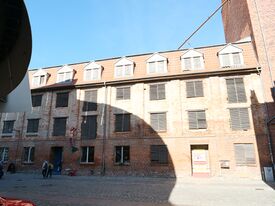 Motormühle Neue Semlower Str., Straßenansicht, 250907
 -
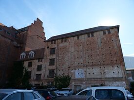 Motormühle Neue Semlowerstr. ,Rückseite, 250907
 -
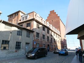 Motormühle Neue Semlowerstr. mit Nachbargebäuden, 250907
 -
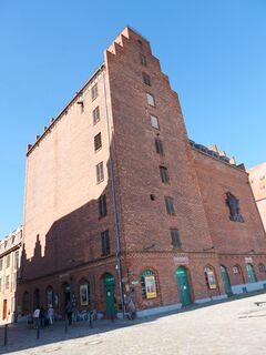 Silo der Motormühle Neue Semlowerstr. , Hafenstr.7, 250907


