Motormühle Gültz: Unterschied zwischen den Versionen
Keine Bearbeitungszusammenfassung |
Keine Bearbeitungszusammenfassung |
||
| Zeile 1: | Zeile 1: | ||
== 1. Standort == | |||
{{Infobox Standort | {{Infobox Standort | ||
| stand = NaT | |||
| landkreis = MSE (AT) | | landkreis = MSE (AT) | ||
| note_landkreis = NaT | |||
| plz = 17089 | | plz = 17089 | ||
| ort = Gültz OT Hermannshöhe | | ort = Gültz OT Hermannshöhe | ||
| Zeile 6: | Zeile 9: | ||
| gemarkung = Gemarkung Hermannshöhe (133953),Flur 4, Flurstücke 45, 46 | | gemarkung = Gemarkung Hermannshöhe (133953),Flur 4, Flurstücke 45, 46 | ||
| gps = 53.759591 / 13.169456 | | gps = 53.759591 / 13.169456 | ||
| note_gps = DenkmalGIS: | | note_gps = DenkmalGIS: 33379325;5958328 | ||
| osm_iframe = <html><center><iframe width="425" height=" | | osm_iframe = <html><center><iframe width="425" height="250" src="https://www.openstreetmap.org/export/embed.html?bbox=13.166475892066957%2C53.75797873680606%2C13.172435760498047%2C53.76120395694014&layer=mapnik&marker=53.75958979218034%2C13.169453144073486" style="border: 1px solid black"></iframe><br/><small><a href="https://www.openstreetmap.org/?mlat=53.759590&mlon=13.169453#map=18/53.759591/13.169456">Größere Karte anzeigen</a></small></center></html> | ||
}} | }} | ||
{{Zweispaltiger Inhalt Beginn}} | {{Zweispaltiger Inhalt Beginn}} | ||
{{Zweispaltiger Inhalt Links Beginn}} | {{Zweispaltiger Inhalt Links Beginn}} | ||
== 2. Denkmalstatus == | |||
{{Infobox Denkmalstatus | {{Infobox Denkmalstatus | ||
| schutzgut = Pferdestall mit Motormühle | | schutzgut = Pferdestall mit Motormühle | ||
| Zeile 17: | Zeile 21: | ||
{{Zweispaltiger Inhalt Links Ende}} | {{Zweispaltiger Inhalt Links Ende}} | ||
{{Zweispaltiger Inhalt Rechts Beginn}} | {{Zweispaltiger Inhalt Rechts Beginn}} | ||
== 3. Mühlenart == | |||
{{Infobox Mühlenart | {{Infobox Mühlenart | ||
| muehlentyp = Motormühle | | muehlentyp = Motormühle | ||
| formtyp = Elektromühle | | formtyp = Elektromühle | ||
| urfunktion = Getreideverarbeitung | |||
| nutzung = Wohnung | | nutzung = Wohnung | ||
| baujahr = 1920 | | baujahr = 1920 | ||
| Zeile 25: | Zeile 31: | ||
{{Zweispaltiger Inhalt Rechts Ende}} | {{Zweispaltiger Inhalt Rechts Ende}} | ||
{{Zweispaltiger Inhalt Ende}} | {{Zweispaltiger Inhalt Ende}} | ||
== | == 4. Bauzustand und Funktion == | ||
=== | === 4.1 Bauzustand === | ||
: | {{Infobox Bauzustand | ||
| bauzustand_jahr = 2025 | |||
| bauzustand = | |||
| stichpunkt_1 = | |||
}} | |||
=== 4.2 Technik === | |||
{{Infobox Technik | |||
| technik_zustand_jahr = 2025 | |||
| technik_zustand = | |||
| stichpunkt_1 = | |||
}} | |||
=== 4.3 Baubeschreibung === | |||
:; Bauweise | |||
:* Aufzählungspunkt 2 | :* Aufzählungspunkt 2 | ||
:* Aufzählungspunkt 3 | :* Aufzählungspunkt 3 | ||
== | == 5. Umgebung == | ||
== | == 6. Standortgeschichte == | ||
== 7. Dokumentation == | |||
== Bildergalerie == | == 8. Bildergalerie == | ||
<gallery widths="275" heights="320" perrow="3"> | <gallery widths="275" heights="320" perrow="3"> | ||
Datei:Motormühle_Gültz_Bild_1.jpg|Bildbeschreibung | Datei:Motormühle_Gültz_Bild_1.jpg|Bildbeschreibung | ||
Version vom 12. August 2025, 21:08 Uhr
1. Standort
Erfasser: n/a, Arbeitsstand: NaT
- Landkreis (1990):
-
MSE (AT)
NaT - PLZ, Ort:
-
17089 Gültz OT Hermannshöhe
- Adresse:
-
Herrmannshöhe 52
- Gemarkung:
-
Gemarkung Hermannshöhe (133953),Flur 4, Flurstücke 45, 46
- GPS:
-
53.759591 / 13.169456
DenkmalGIS: 33379325;5958328
2. Denkmalstatus
- Schutzgut:
-
Pferdestall mit Motormühle
- Listeneintrag (seit ...):
-
DL-MSE-DM: 489
3. Mühlenart
- Mühlentyp:
-
Motormühle
- Formtyp:
-
Elektromühle
- Urfunktion:
-
Getreideverarbeitung
- Nutzung:
-
Wohnung
- Baujahr:
-
1920
4. Bauzustand und Funktion
4.1 Bauzustand
- .. im Jahr 2025 :
- Zustandsbeschreibung:
4.2 Technik
- .. im Jahr 2025 :
- Zustandsbeschreibung:
4.3 Baubeschreibung
- Bauweise
- Aufzählungspunkt 2
- Aufzählungspunkt 3
5. Umgebung
6. Standortgeschichte
7. Dokumentation
8. Bildergalerie
-
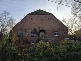 Bildbeschreibung
 -
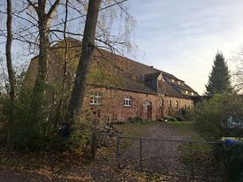 Bildbeschreibung
 -
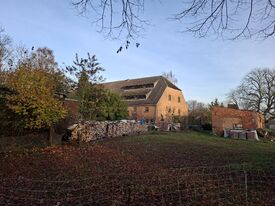 Bildbeschreibung


